|
|

|

|
About measurement methods of air dose rates by KURAMA-II.
What is KURAMA?
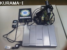
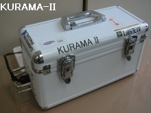
KURAMA (Kyoto University RAdiation MApping system) is a car-borne survey system developed by the Kyoto University Research Reactor Institute. The system is designed to survey air dose rates over wide areas in detail and in a short time using a large number of common vehicles, unlike the existing monitoring cars specialized for precise measurement. An in-vehicle unit of KURAMA-I is produced at a low cost, consisting of consumer products such as GPS and a laptop PC. KURAMA-II has become more compact and robust while achieving full automatic measurement.
Features
KURAMA-II is a compact and easy to operate system. KURAMA-II immediately sends measured data through mobile phone networks and stores the data on servers connected to the Internet, while allowing us to check the data on a monitor. This enables us to respond quickly to problems, leading to flexible and efficient survey.
Measurement methods
A unit of KURAMA-II is installed in a route bus, basically behind the backseat center-line side. From the engine start to stop, the system obtains dose rates and and location data every three second and continues to send the data. Because it measures data at the same interval of time, distances vary between survey points. Measurement data is obtained roughly every 30 to 100 m at the normal operating speed of route buses.
Correction of air dose rates
This site uses data made the following correction to measured data by KURAMA-Ⅱ. This process adjusts the characteristics of the detector system circuit and converts the data to air dose rates 1 m above the ground outside the bus.
H (corrected dose rate inside a bus) = M/(1-0.0027×M) :M is a measured dose rate
Air dose rate after correction = 1.6 (correction coefficient) × H (corrected dose rate inside a bus)
Correction of location data
KURAMA-II obtains each measurement location data using a GPS receiver, which has possibilities to cause errors due to signal problems. In order to correct the location data, the following are processed.
・Removing data without precise location.
・Correcting location data according to the digital road network data.
・Removing data measured in tunnels and on roads under the elevated rail tracks where are uncontaminated.
Mesh processing
Measured data at each survey point is summarized roughly every 100 x 100 m section and averaged on a weekly basis. The average value represents a dose rate in the section. The 100 x 100 m mesh is employed in consideration of measurement accuracy of GPS (±10 m) and contribution degrees of gamma rays from Cs-137 and Cs-134 distributed around survey points.
Data calculation of variation with time
To calculate variation in air dose rates with time, measured data within a mesh is averaged on a monthly basis. The average value represents a dose rate of the month.